Beacon Hill and Brookvale MWHS
For perhaps 40,000 years to 65, 000 years before the British first arrived at Sydney, Aboriginal people roamed the local area in small groups hunting and gathering food. Governor Phillip led the first British exploration of the district, starting at Manly and trekking for three days, 15-18 April 1788.
It is sometimes said, but cannot be confirmed, that this expedition climbed Beacon Hill.
The explorers were certainly nearby however, being known to have camped one night in present-day French’s Forest.
On Governor Macquarie’s direction, an Irish-born former convict, James Meehan, surveyed the first land grants in the area, beginning in 1814.
By this time the local Aboriginal people were in sharp decline. They had been decimated firstly by contact with European diseases, to which they had no immunity, then increasingly displaced in the wake of settlement.
The first landowner of Beacon Hill was Daniel Egan who purchased 80 acres (32 hectares) around the summit on 31 December 1857.
At that time the closest road was the Brookvale stretch of Jenkins’ road to Pittwater, now called Old Pittwater Road. Since 1822 this road had run through Miles’s gully, near the foot of present day Beacon Hill Road - then only a rough track linking Jenkins’ Road with French’s Forest.
To assist surveys of the district, observations were made in July-October 1879 for a ‘Trigonometrical Beacon’ above a waterfall behind Miles’s gully.
This was built by the Department of Lands in 1881 and formally sited by Surveyor J. Brooks in August that year.
A trig. station continues to be maintained on the hilltop to this day, the name Beacon Hill being derived from it.
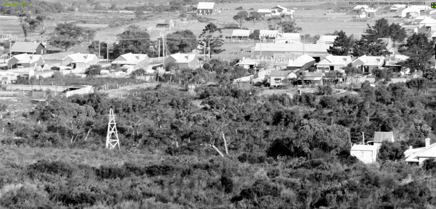
Brookvale NSW 1917
In the land boom of the 1880’s, Brookvale was subdivided and a small township began to grow, complete with a school and church, both opened in 1887.
A public reserve on Beacon Hill was first gazetted in 1888 but revoked in 1907, prior to the granting of a lease to Beacon Brick Company, formalised on 21 April 1909.
This lease was situated north of the Reserve, generally bounded by present-day Gilles and Biralee Crescents.
The Company quarried clay and shale, and also a purer white clay called kaolin, suited to the making of porcelain. The main worksite opened in 1910, sited near present-day McKillop Road.
Here the ore was hand-loaded into small hoppers, on temporary rail tracks radiating out from a central loading platform. It was then loaded into skips that descended via a miniature railway to the Brookvale brickworks owned by Manly Brick and Tile Company.
The two companies merged in 1925, but were closed in 1936, when absorbed into a large consortium named Brickworks Ltd. Brickworks Ltd closed its Brookvale production because of the building decline caused by the 1930’s depression, then after World War 2 building recovered, and local brick making reopened in 1946.
At the Beacon Hill quarry, bulldozers and trucks superseded the rail system and mining continued until the quarry was virtually worked out in 1962.
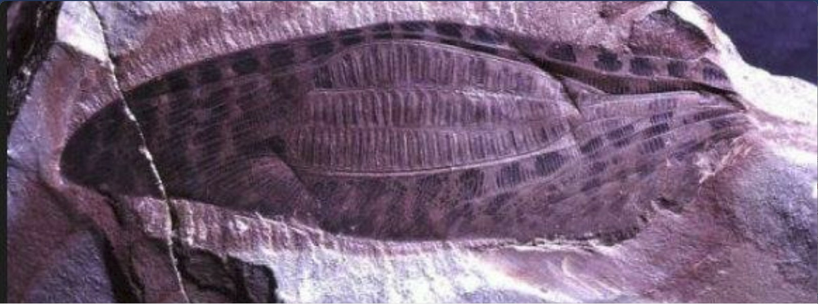
Clatrotitan andersoni Mckeown,Triassic. Beacon Hill, Brookvale NSW
A special by-product of the quarry was some amazing Triassic age fossils - up to 220 million years old. They were casually picked up by miners and locals, mostly while the excavation method was still pick and shovel.
Triassic Specimens Beacon Hill
Some unique examples of prehistoric fish, plants and insects were passed on to the Australian Museum in College Street, Sydney, where they duly received quaint identifying names such as the genera ‘Brookvalia’ and 'Beaconia’.
The crest of Beacon Hill remained as scenic bushland on crown land. To help ensure its preservation, the Manly Warringah and Pittwater Historical Society (MWPHS) sought Warringah Council approval in 1929 for a hilltop monument in honour of Governor Phillip.
From 1937, the military occupied the hilltop in a defence facility called ‘Brookvale Observation Post’.
Just below the rocky crest, a concrete bunker was built with a 180 deg. window viewing the sea for any enemy activity. Then in mid 1940, the crest was levelled for a range-finding facility in a small fibro and tiled-roof cottage, disguised to look like a residence.
Staff plotted the trajectory of shells, which was then phoned through to the gun sites at North Head and Middle Harbour BY FIELD PHONE.
Also built, was a small radar station facing the sea above the bunker. Designed experimentally by the CSIRO, it operated in conjunction with similar radar posts at Bluefish (near Shelley Beach) and Dover Heights.
Radar Station Beacon Hill 1950's
After the War a new radar station further west, beside Warringah Road, took on a more modern defensive role. From here on, the hilltop buildings became disused and were eventually dismantled, the cottage being the last to go in 1965.
Coinciding with the army’s withdrawal, community moves were made to restore Beacon Hill as a public reserve.
Coinciding with the army’s withdrawal, community moves were made to restore Beacon Hill as a public reserve.
Download the PDF
| beacon_hill_and_brookvale_mwhs_-_john_relph_27.11.2017.pdf |
