PEDESTRIAN AND CYCLE BRIDGE
PITTWATER ROAD
NARRABEEN LAGOON
Date Loaded to Website 11 August 2018
Source Northern Beaches Council Website
https://yoursay.northernbeaches.nsw.gov.au/narrabeenlagoonbridge
To improve safety and access for all users, Northern Beaches Council in partnership with Transport for NSW are proposing to build pedestrian and cycle bridge alongside the existing bridge at Pittwater Road, Narrabeen.
COMMENT:This new combination pedestrian /cycle path only serves the southern side, what about the northern side, it still will have the existing old narrow pathway against the road edge, so how is this proposal going improve safety and access "for all users"?
COMMENT: What will happen to the current pathway on the southern side when the new one is finished, will it simply be blocked off? Council state no work on the traffic section of the bridge is planned at this stage.
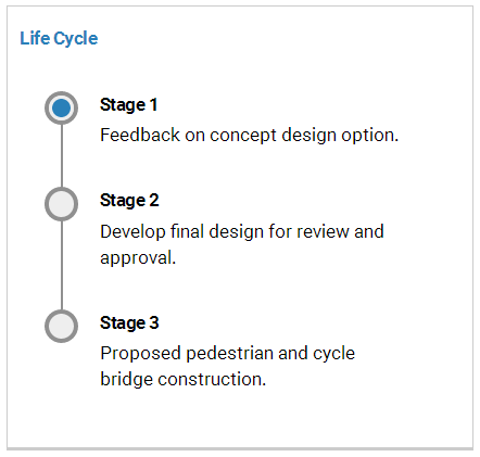
Learn More and Have Your Say
We are proposing to build a new pedestrian and cycle bridge at Pittwater Road, over Narrabeen Lagoon.
View concept designs here
We are seeking your feedback on the aesthetic elements of the concept design.
View concept designs here
We are seeking your feedback on the aesthetic elements of the concept design.
How to be involved
Comment online
- Write (marked 'Attention: Pittwater Road Pedestrian and Cycle Bridge Narrabeen Lagoon') to Northern Beaches Council, PO BOX 82 Manly 1655.
- Come along to one of the information drop-in sessions
Information Drop-In Sessions
Berry Reserve, Narrabeen (near the Pittwater Road bridge)
For enquiries contact Kristen Montgomery 9942 2769 or Jen Moody 9942 2755.
Comments close Sunday 2 September 2018
- Thursday 2 August 10.30am - 12.00pm
- Wednesday 8 August 2.00 - 4.30pm
- Sunday 12 August 9.00am - 12.30pm
- Sunday 26 August 9.30 - 11.00am
For enquiries contact Kristen Montgomery 9942 2769 or Jen Moody 9942 2755.
Comments close Sunday 2 September 2018
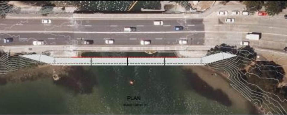
The Proposed Pedestrian and Cycle Bridge
The proposed multi-use bridge will be a three metre wide pedestrian and cycle bridge located three metres to the west of the existing road bridge.
The piers of the new bridge will be aligned with those of the existing bridge to maintain navigational channels beneath the bridge.
During extreme storm events Pittwater Road Narrabeen is subject to flooding. To reduce the flood risk and to comply with current bridge design standards, the height of the new multi-use bridge will need to be elevated above the height of the existing bridge.
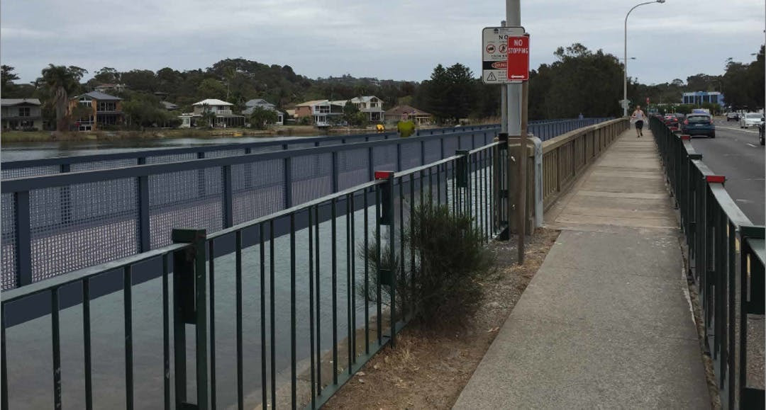
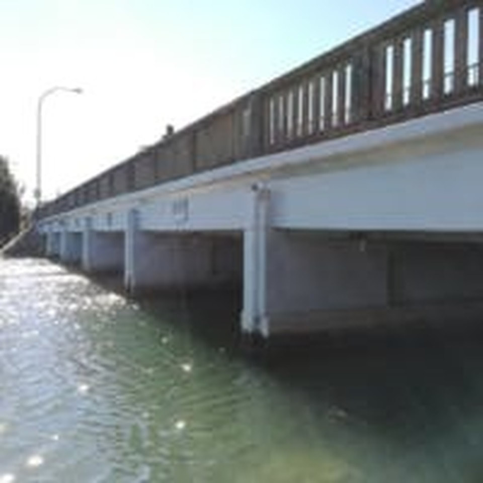
The Existing Pedestrian and Cycle Bridge
The existing bridge along Pittwater Road, Narrabeen, was built in 1946 (view photo). Due to the narrow width of the existing pedestrian path on the western side of the bridge, it is not suitable to be used as a shared path.
The existing road bridge has a limited lifespan and when it is upgraded it will be constructed to a higher flood level to comply with current bridge design standards (to the same level as the new pedestrian and cycle bridge).
We are not proposing to upgrade the existing road bridge as part of this project.
Background
Narrabeen Lagoon Trail, an 8.4km multi-use trail circumnavigating the lagoon was completed in 2015. Since then, several sections of the trail have been identified as requiring an upgrade to ensure the safety of all users.
The section of path across the Pittwater Road Bridge has been identified as a bottleneck and safety hazard for cyclist and pedestrian users of the bridge.
Council currently has funding from Transport for NSW’s B-Line project to improve pedestrian and cycle links along Pittwater Road. These funds will provide a three metre wide pedestrian and cycle bridge alongside the existing road bridge, eliminating the current pinch-point and increasing safety for users of the bridge and trail.
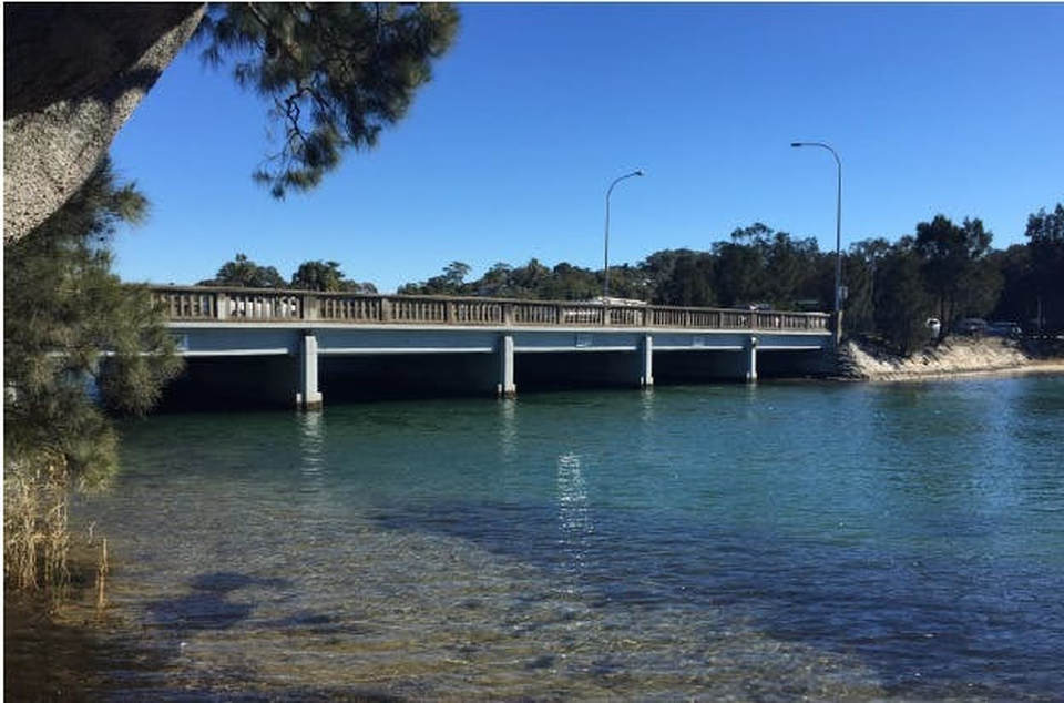
Current Narrabeen Lagoon Bridge Pittwater Road
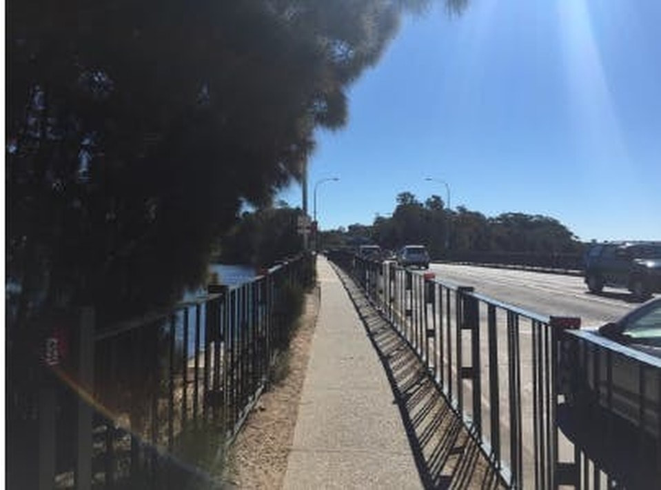
Current Pedestrian Path (South Side) on the Narrabeen Lagoon Bridge Pittwater Road
Why are we doing this project? The Pittwater Road Bridge over Narrabeen Lagoon is a key section along the Narrabeen Lagoon Trail and a significant north-south link for pedestrians and cyclists.This path is a known area of conflict for pedestrians and cyclists due to the width of the existing bridge.To improve safety and access for all users, Northern Beaches Council in partnership with Transport for NSW are proposing to build a pedestrian and cycle bridge alongside the existing bridge at Pittwater Road, Narrabeen.
How is this project funded? The bridge is funded through a grant from Transport for NSW and supplemented by funding from Councils Stronger Communities Fund.
When is the new bridge likely to be built? The bridge is likely to be open for use in 2020.
Who will use the new bridge? The users for the proposed shared path bridge include; students, commuters, walkers and cyclists.
How many piers does the proposed design include? The proposed bridge would have 5 piers between abutments.
Will the new bridge impact the ‘functional navigation channels’? No. The new piers will align with the piers on the existing bridge to avoid obstruction of the navigation channels.
Why will the bridge be higher than the existing bridge?The bridge will be designed to comply with a 100 year flood level. The existing road bridge will eventually be replaced and will also be built to this elevated level.
If the bridge is elevated, how will the bridge comply with accessibility requirements? The bridge will have ramps at either end to ensure accessibility.
Why can the existing bridge not just be widened? The RMS has rejected this as an option as they are concerned about additional loads on the aging bridge.
What will the bridge look like? The bridge will be a half through truss bridge (as per concept); however Council is seeking feedback on the colour and material palette to incorporate into the concept design.
Why is Council proposing to build a truss bridge? This is the most economical form of bridge for the location and site constraints. It will also ensure ease of installation.
What will the bridge be made of? The bridge is expected to be made of steel with fibre reinforced polymer decking.
Will the bridge be covered or have a cage over it like other road bridges? The bridge will not be covered.
What Environmental assessments have been done so far? As the bridge is only a proposal at this stage, only a preliminary assessment of the proposed bridge impacts on the environment has been undertaken.This includes site visits and desktop assessment of the available information to determine what may require further investigation. As the proposal continues to develop, detailed environment assessments will need to be undertaken. This will include assessment of impacts to flora and fauna (both marine and terrestrial), waterway impact assessments, and species impact statements.
How will lagoon Seagrasses be affected? Seagrasses have been identified in preliminary investigations on the northern and southern shores of the project area. Any impacts to marine seagrasses requires approval by The Department of Primary Industries and will require significant mitigation of the impacts, such as repositioning of bridge piers and abutments, or allowing sunlight to pass through the bridge with grated decking materials. Further assessment of the environmental impact and mitigation measures will be developed through the environmental assessment and approval stage.
How will trees be impacted by the proposal? The endangered ecological community Swamp Oak Forest has been identified in preliminary investigations on the northern foreshore. The removal of these trees would require approval and the design would be required to show that it has the least impact on this ecological community. Further assessment of the environmental impact and mitigation measures will be developed through the environmental assessment and approval stage.
Will there be additional lighting? Additional lighting is not proposed as part of the bridge.
How much of the reserve will be taken up with the accessible ramps? To achieve the clearance height, the ramps will have to extend approximately 18 metres into the reserve at either end.
The existing boardwalk decking is very noisy. Will the same decking be used on the bridge? It is proposed to use the same decking as the existing boardwalk and bridge, however noise will be reduced through the use of rubber bearing pads.
Will access through the water way be maintained? Access will be maintained however, during construction, there may be periods where it is closed for safety reasons (i.e. during crane lifts).
Will the trail remain open during construction? Access will be maintained however there may be periods where this particular section is closed for safety reasons (i.e. during crane lifts).
Why is there an offset from the existing bridge? The bridge is offset from the existing bridge by 3 metres so that maintenance activities can be undertaken to both bridges and also to allow sufficient space for the bridge replacement to be completed.
KEY DATES
2 August 2018
Info Drop-In Session
10.30am – 12.00pm
Berry Reserve, Narrabeen
08 August 2018
Info Drop-In Session
2.00 – 4.30pm
Berry Reserve, Narrabeen
12 August 2018
Info Drop-In Session
9.00am – 12.30pm
Berry Reserve, Narrabeen
26 August 2018
Info Drop-In Session
9.30 – 11.00am
Berry Reserve, Narrabeen
02 September 2018
Comment Form Close
Online comment form closes Sunday 2 September.
Info Drop-In Session
10.30am – 12.00pm
Berry Reserve, Narrabeen
08 August 2018
Info Drop-In Session
2.00 – 4.30pm
Berry Reserve, Narrabeen
12 August 2018
Info Drop-In Session
9.00am – 12.30pm
Berry Reserve, Narrabeen
26 August 2018
Info Drop-In Session
9.30 – 11.00am
Berry Reserve, Narrabeen
02 September 2018
Comment Form Close
Online comment form closes Sunday 2 September.
Key Dates
|
T
02 August 2018 Info Drop-In Session 10.30am – 12.00pm Berry Reserve, Narrabeen 08 August 2018 Info Drop-In Session 2.00 – 4.30pm Berry Reserve, Narrabeen 12 August 2018 Info Drop-In Session 9.00am – 12.30pm Berry Reserve, Narrabeen 26 August 2018 Info Drop-In Session 9.30 – 11.00am Berry Reserve, Narrabeen 02 September 2018 Comment Form Close Online comment form closes Sunday 2 September. |


|
Leave a comment on Northern Beaches Council Website
https://yoursay.northernbeaches.nsw.gov.au/narrabeenlagoonbridge?tool=survey_tool&tool_id=feedback-form-narrabeenlagoonbridge#tool_tab
https://yoursay.northernbeaches.nsw.gov.au/narrabeenlagoonbridge?tool=survey_tool&tool_id=feedback-form-narrabeenlagoonbridge#tool_tab
Download the 2 Files
| new_pedestrian_bridge_narrabeen_lagoon_alignment_constraints.pdf |
| new_pedestrian_bridge_narrabeen_lagoon_elevations.pdf |
